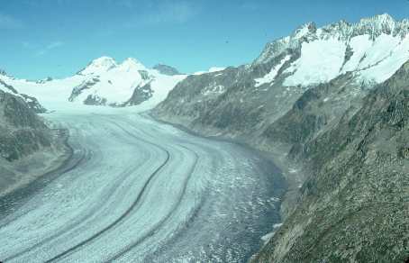
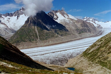
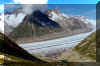
Aletsch
The special of the glacier region with the longest glacier in
Switzerland is, that
access is easy and the ice stream can be admired from above.
The area is included in the World Heritage List of the United
Nations.
It offers opportunities for
hiking and Winter-skiing.
Between Riederalp and Bettmeralp a shuttle
service is provided.
 |
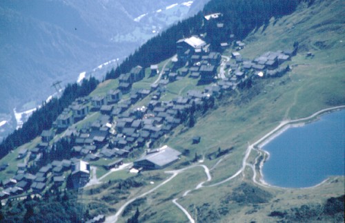
Bettmeralp |
 | Fiescheralp (Kuehboden): Located above Fiesch it's the
middle station of Fiesch-Eggishorn cable car. Directly from the
Matterhorn-Gotthard-Bahn (MGB) Railway station the new Gondelbahn
(2019) brings you up to Fiescheralp.
The "must
see" are Eggishorn with breathtaking view over Aletsch
glacier and the Maerjelensee area where the ice masses make a
bend.
www.aletscharena.ch/destination/orte/fiesch/
|
| Bettmeralp: above Betten village. A large Cable car operates
directly between Betten/MGB Station and
Bettmeralp, while a smaller system runs in two sections by
Betten village. Bettmeralp is comfortably located in the center
of the Aletsch region. A "must" is Bettmerhorn with
fantastic view and a large Restaurant. You can walk up there or
use the cable car from Bettmeralp. (My preferred hike to
Bettmeralp although is from Fiescheralp).
www.bettmeralp.ch
|
| Riederalp: above Ried/Moerel is close to the Aletsch forest.
From Moosfluh you get a fantastic view over the glacier as well.
www.riederalp.ch
|
| Aletschwald nature reserve with villa Cassel as
education center on Riederfurka (30 Minutes walk from
Riederalp). Pro natura, the caretaker of the protected area,
organizes tours/seminars/workshops.
Villa Cassel offers accommodations
in the lovely old building.
Book:
Aletsch Eine Landschaft erzählt,
Laudo Albrecht
Rotten Verlags AG Visp
in German |
|
Top of page
Hikes from Bettmeralp, Fiescheralp:
Here some interesting hikes from Bettmeralp.
The routes can easily be
adapted to your wishes, since there are many tracks to choose from. Cable cars and chair
lifts are the easy way to or from the top.
 |
 |
| Along Aletsch glacier |
In the Aletsch forest |
Top of page
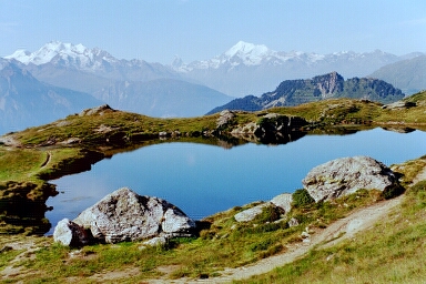
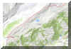
| Bettmeralp-Blausee-Riederfurka |
km |
hrs |
Bettmeralp-Bettmersee-Blausee-Unterer Weg-Riederfurka-
Oberer Weg-Blausee-Bettmersee |
12 |
7 |
You may cut the hike by using the shuttle to Riederalp
and return on the track as mentioned here.
From Riederalp there is a cable car to Moosflue which is a bit above
Blausee, giving additional choice of trails.
You may also use the chair lift from Riederalp to Hohfluh.
First we walk along the Bettmersee. The track to Blausee is
clearly marked. It crosses the alp meadow. Some time later the climb
will get a bit steeper.
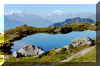 |
Blausee |
After Blausee there is some more climbing, but after a
few minutes we're on the verge of the mountain range with a
undisturbed view into the glacier area. There are different trails
to Riederfurka. One runs along the rim and the fence of the
protected area, then there is an upper and a lower track and one on
the very bottom of the forested area.
Choosing the lower track (unterer Weg) we enjoy walking in the
unique forest of old pines (Arve), the larger ones are hundreds of years old. There are dense shrubs of Alp roses and berries.
At Riederfurka with Hotel, Restaurant and Kiosk we' re amazed by
the old "villa Cassel", a peculiar building. It is used for Seminars, meetings etc.
Don't
miss the exhibition in the house and spend some time in the very
informative "Alpengarten" right at the villa. If rooms are
available you might be able to spend the night in one of the old,
romantic rooms of villa Cassel.
Back to Bettmeralp we're using the "Oberer Weg", we'll
have many fantastic views toward the upper section of the glacier.
A good option for proceeding to Bettmeralp is by way of Biel.
From there we're descending behind Bettmersee.
Top of page
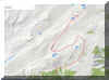
| Bettmeralp-Kuehboden-Maerjelen |
km |
hrs |
Bettmeralp-Furri Huette-Kuehboden-
Taelligrat-Maerjelensee-Aletschtrail-Bettmerhorn |
14 |
7 |
| Bettmerhorn-Bettmeralp (cable car) |
|
|
To shorten this hike you may use the chairlift
Bettmeralp-Schoenboden and/or the cable car Kuehboden-Eggishorn with
descent from Eggishorn to Taelligrat.
For the first part of this hike we're using the track from
Bettmeralp up to Furrihuette. From there it's a good gravel road to
Kuehboden with hotels, Restaurants and the middle station of the
Fiesch-Eggishorn cable car.
From Kuehboden we're proceeding on the comfortable road towards
Maerjelen. After about one km we arrive at the site where some time
ago the "old Hotel Jungfrau" has been. Some foundation is all that's been left after
a fire. About 20 m before, we
recognize the marking on a rock, pointing up to Eggishorn. The foot
track will get a bit steep, but it's well worth the trouble.
If you want it easier, you may proceed on the gravel road.
Later there will be a tunnel of about 1 km which will lead to the
artificial lake and the Gletscherstube (Restaurant).
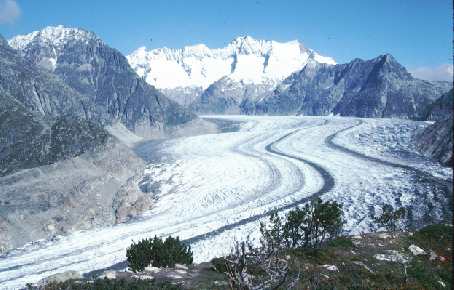
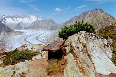
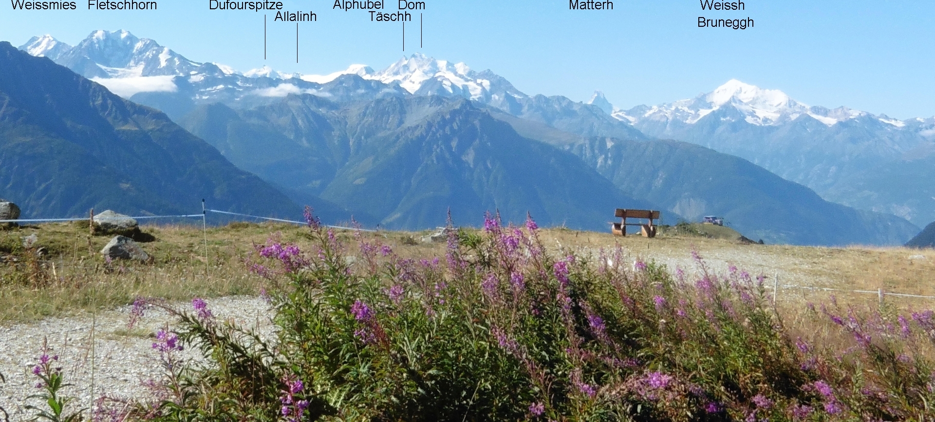
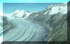
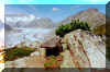
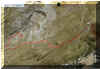
From Taelligrat we enjoy a fantastic view: the Aletsch glacier, Jungfrau region, Strahlhorn
and Fiescher glacier just across.
 |
Fiescher glacier |
 |
Aletsch glacier
Maerjelen valley |
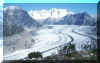
From this excellent viewpoint we descend to Gletscherstube. There
is a marker pointing straight down to little Maerjelensee. Although
the track is not marked, you won't miss the lake.
Maerjelen is where Aletschgletscher makes a bend and polished
rocks from times gone by and the icy flanks of the glacier can be
seen. Don't walk on the glacier without a licensed guide
(Bergfuehrer).
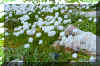 |
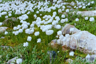
Wool grass |
After a break we proceed above the glacier on a small but
excellent track. At Roti Chumme we turn left and ascend
towards Bettmerhorn. At first the pace is comfortable, but later we
have to climb some stairs and it's a steep climb. At the top, on
Bettmerhorn we'll be rewarded with a remarkable view.
 |
On the track to Bettmerhorn |
After a well earned drink we board the cable car for Bettmeralp.
On the lower part before entering Bettmeralp, still in the steep
slopes with rocks and lush alpine grass we'll probably recognize
Marmots. They ignore the cable car cabins above.
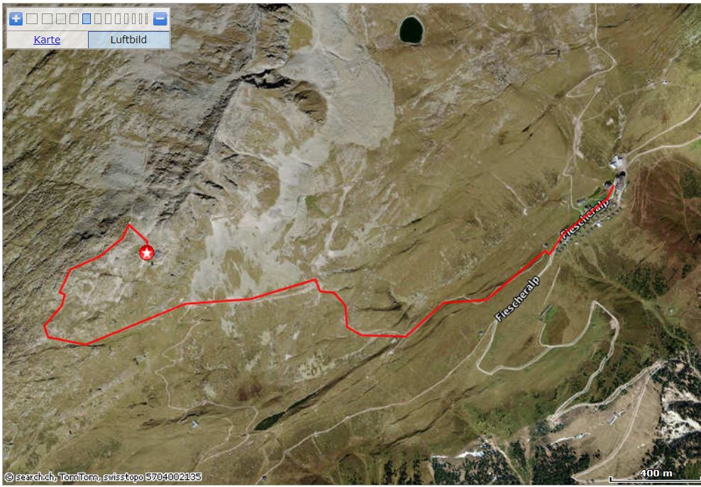
Start for the above mentioned route is Fiescheralp. Access is by
Gondelbahn from Fiesch MGB-station.
4.5 hrs.
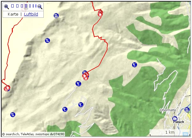
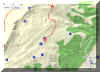 Interactive
map: Interactive
map:
http://map.search.ch/d/te5njnknd
GPS-File:
GPS_Data/GPX-Fiescheralp-Bettmerhorn.zip
Fiescheralp-Bettmerhorn direct
1.5 hrs. First take the road towards Bettmeralp. After the last houses
a road to the right heads up towards Bettmerhorn. The road is well marked.
 Interactive
map: Interactive
map:
http://map.search.ch/d/wnkmdhkzj
GPS-File:
GPS_Data/GPX-Fiescheralp-BettmerH-direkt.zip
Fiescheralp-Bettmeralp via Laxerstafel
GPS-File:
GPS_Data/Fiescheralp-Ls-Bettmeralp.gpx.zip
interactive map:
https://map.search.ch/d/tazmjfkm2?pos=651294,139807
2 hrs
This is a less traveled path, which partly follows an old Suone, the 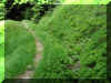 Baergera
(there are other Suonen with the same Name).
The former water channel is largely overgrown and now serves as a lovely hiking
track, partly passing wooded areas. Baergera
(there are other Suonen with the same Name).
The former water channel is largely overgrown and now serves as a lovely hiking
track, partly passing wooded areas.
First we follow the road towards Bettmeralp. Shortly, another driveway to
the left is heading for the Skilift below. After two large bends a small
path to the left brings is to the start of the hiking track. The marker
though can easily been overlooked.
A very interesting website (in German) with inventory and a lot of
interesting details including photos and maps is here:
http://www.suone.ch/suonen/
Fiescheralp-Moosfluh-Riederfurka-Riederalp
 GPS-File: GPS-File:
GPS_Data/Fiescheralp-Moosf-Riederalp.gpx.zip
GPS_Data/GPX-FiescherAlp-Blausee-BAlp.gpx.zip
interactive map:
https://map.search.ch/d/gq1ztm0y2?pos=649636,139020
3 hrs
After the climb to Hohbalm, 45 minutes from the Restaurant 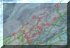 Bettmerhorn,
the path follows more or less the rim above the glacier. Bettmerhorn,
the path follows more or less the rim above the glacier.
An alternativ route is to Blausee (the middle station of Moosfluh Cable
car) and down to Bettmeralp.
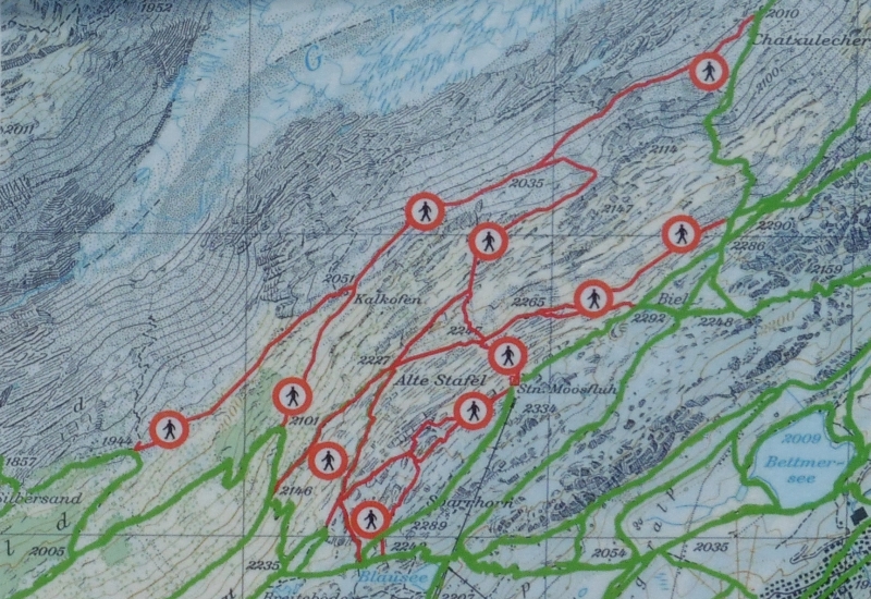
At Moosfluh, due to rock-and landslides on the glacier side, lower
tracks had to be closed. See the photo (June 2017) of one of the
info-boards. The cable car Riederalp-Moosfluh is not affected and runs as
usual.
The system can be adjusted to future changes in the environment:
https://www.doppelmayr.com/en/products/references/68-cgd-riederalp-blausee-moosfluh/
Top of page
| Bettmeralp-lower Aletsch trail |
km |
hrs |
Bettmeralp--Biel-Kalkofen-turnoff for Belalp-unterer Weg-
Biel-Bettmersee-Bettmeralp |
10 |
3 |
This is a shorter, but quite interesting tour. We follow
the markings for Biel. In the morning, when it's quiet yet, Marmots
can be seen feeding around the rocks and on the alp pastures.
Reaching the top we proceed to Aletschwald.
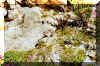 |
Marmots along the hiking trail |
Entering the reserve
we head for Kalkofen, which will get us to the lower ones of the many
tracks. We will find a reconstructed site where the predecessor of today's
cement was won. The base material, limestone and wood for the fire
was gathered in the area. The lowest track is also the youngest part
of the flora and the larch trees in the stony environment are a different
picture from the old arolla pines above. We proceed on the lowest
track until we reach the turnoff for the track across the glacier to
Belalp. (Don't enter the glacier without licensed guide). At the
turnoff we proceed to the Oberer Weg. According to taste we may add
to the route or return by one of the exits either by Blausee or on
the same track we came from. Option: From Moosfluh is a cable
car, from Hohfluh a chair lift available. From Riederalp it's a 30 Minutes walk to
Bettmeralp (also a shuttle service is available). |