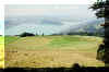
From Wildspitz there is a path down to Alpli, directly from the peak. I propose
to make a detour to Gnipen. It's an easy walk and
we get to see the area where two hundred
years ago part of the mountain broke off and Goldau was buried under the rubble.
The lookout is
superb. By following the path on the right, a turnoff
follows after 100 m on right leading down to Oberalpli/Alpli. Going straight on
there is another, steep track down to Alpli. Some climbing will be
necessary and on the uppermost part there is a rope for pulling yourself up or
for climbing down.
Both tracks can be wet and dirty and therefore
slippery, but the first one is less steep and there is no climbing
involved (the track is called the Winterweg).
Alpli is a very
popular place.
From Alpli a grass track just at the end of the outside part of the Restaurant leads to the
forest and down to Unteraegeri by way of
Urzlenboden and then on to Schoenalphuette.
As an alternative to the descent to Alpli: at Gnipen we
can walk along the ridge to the cross and down to the lower rim. The path runs
then down along the cut to Spitzibuel, Goldau (2 hrs); it's a steep track. From
Goldau we may catch a train back to Zug.
Top of page
This track too, runs at first from the Bus stop in the general
direction Huerital. The hiking signs guide us to the right, a bit off the
Bitumen road, along meadows and farm houses. At the saw mill we'll be
back on the driveway. At the end of the halls and the timber yard, at
Roggenbruecke, we cross Hueribach.
Soon the road is ascending a bit steeper and at Resti we may enjoy the
view over to Zugerberg/Hochwacht, a bit of the Albis chain, Gubel,
Aegerisee, Unter/Oberaegeri, Hoehronen.
Soon we get to the crossroads where we'll turn right for Brandhoechi. At
the little shack we have a fine view again, but then the track gets steeper
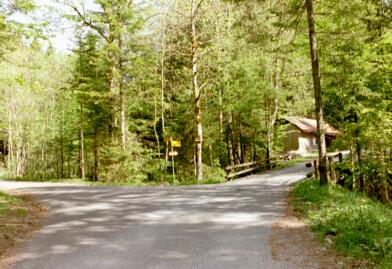
up the forested hill. Yellow arrows on trees show the proper route.
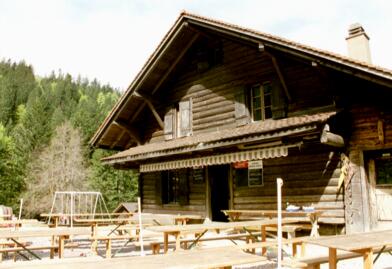
Brandhoechi with Summer Restaurant Brandalp and children's playground
invite for a rest.
We move on to Rossallmig.
From here the road straight on will lead to Cholerhuette and Ramenegg/Halsegg
and on to Wildspitz.
We choose the track to the left for Nas.
After some 20 m we are on the forest track to Sod, Nas, Unteraegeri.
On sequent crossroads we choose the direction for Nas, Morgarten.
Arriving at Nas, the larger of two camping parks (Kiosk), we have two
options: either along the Aegerisee to Unteraegeri (about 80 Minutes), or
to the Bus stop at the Hotel/Restaurant Morgarten (30 Minutes).
Top of Page
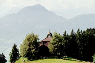
On the way along the Aegerisee and on to Sattel we're passing a
historic landmark: at the end of the lake at Morgarten
a memorial is reminding of the battle in this region. Before
reaching Sattel a chapel stays where the ambush has taken place.
Two trails to Wildspitz are marked:
one from the southern side of Sattel
Railway Station by Herrenegg, Moos, Lutzi to the Obhaeg chapel and to Wildspitz (2.5 hrs),
the other from Bus stop "Bauernhof" at the
Ford Garage / "AVIA" filling station, ascending by Halsegg. That's our choice.
From the Sattel Railway station it's about 80 m back to the main road,
then to the left, crossing the Railway line. After 100 m we're at the
memtioned Ford
Garage. There the trail begins, at first as a Bitumen road in a
residential area. At the last house, to the right, the track begins.
Partly by stairs we gain height quickly. From time to time we enjoy the
view. The better known mountains are Fronalpstock, Rigi, Uri Rotstock. Two
or three times we hit the Bitumen road, but after 100m we're on the hiking
track again.
Already after an hour the last ascent to Halsegg commences over the Alp
meadows. The track runs in a little valley, parallel to the electric power
line. At a large pine tree we're passing a gate to Halsegg (Retaurant
closed Thursdays)
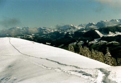
From Halsegg we're proceeding to Wildspitz
and Gnipen on a comfortable nature path. Here we enjoy the view over Schwyz
valley-plains and
into the mountains.
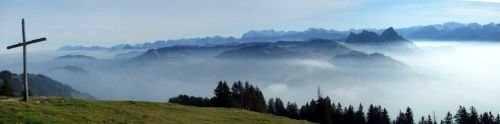
From Gnipen a track leads down to the big iron cross and a
resting place. For Goldau we may chose the track straight along the rupture,
or the slightly longer track by Ochsenboden.
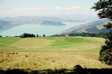
By way of Ochsenboden we often have undisturbed view over Zugersee
and Zugerberg (Walchwilerberg).
After about 20 Minutes we have reached the
lower outcrop. Clearly to see is now the edge where the mountain has broken
off.
The track down to Spitzibuel/Goldau follows more or less a straight
line down the hill. From time to time, marks on trees and rocks reassure
us that we're on the right track. Some distance later the track crosses
the forest and after 1.5 hrs we're at Unt.Spitzibuel.
After Unt.Spitzibuel first the route runs along the Bitumen road, but
at a little stable a track again turns off to the right. Keeping to the
right we're on the track down to Goldau.
Here in Goldau we're walking inside a tidy residential area and we'll
be lead to the Railway station.
Top of page
The beginning of the tour is right at the information board at Sattel
Railway station and bus stop (general direction "Lutzi-Wildspitz"), SE of the
station. After some 300 m turn right and under cross the railway line. The
first part of the track is also marked "Rundweg Moos"
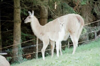
For the first half hour the Bitumen road is ascending steady until we 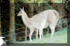 reach "Lama Hof" (Llama farm). The tall teepee's can be
recognized from some distance. The track continues soon as gravel road.
reach "Lama Hof" (Llama farm). The tall teepee's can be
recognized from some distance. The track continues soon as gravel road.
On my tour end of July 02 the Llamas where feeding or resting peacefully
on the pasture the track is crossing. I was observed intently, but
otherwise ignored.
The track crosses meadows and often there are fine views. Soon the path gets a bit rugged, a gully has to be crossed.
 After a while we are directed to the Bitumen road again, but soon we're on a forest hiking track again, in a area full of rocks.
At chapel Obhaeg (Fatima chapel. In summertime mass on Sunday mornings) we have earned a short rest. Far above clearly visible our goal:
Wildspitz.
From the chapel the path is steeply ascending. In half an hour it's done,
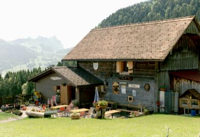
although half way up Alp Restaurant Gehren is inviting the thirsty ones.
On Wildspitz a comfortable road is leading to Gnipen. There we follow the
rim all the way to the Christian cross. There a steep track right through
the rocks leads down to Spitzibuehl.
Our track though is to the right and
follows the rim down to the little hut (same route as mentioned in the
Goldau trail).
 At the hut acute-angled to the right the path is leading towards
Rufiberg. The lovely forest track is zigzagging down to the Rufiberg
plains.
At the hut acute-angled to the right the path is leading towards
Rufiberg. The lovely forest track is zigzagging down to the Rufiberg
plains.
As an alternative, there is the road to Duerrenboden and on by Walchwiler
Oberallmend to Zugerberg funicular station.
For us it's straight on, partly on Bitumen road and partly on forest tracks
towards Holaesch, Utenberg, finally by Hotel/Restaurant Aesch to Walchwil.
From Aesch to Walchwil Bus stop it's about 15 Minutes.
 Active
map:
Active
map:
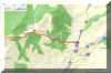
http://map.search.ch/d/ti3mjq4yj
GPX-route:
GPS_Data/GPX-Sattel-ZgBerg.zip
(6 hrs) Here another route from Bus Stop "Bauernhof" (Bus Line 9 of ZVB,
Aegeri-Sattel)
to the Zugerberg funicular station.
The route to Gnipen is similar to the above mentioned, but at Gnipen we
turn North.
For those who hate steep descents with rock climbing, there is a turn
off for the path by Alpli (the "Winterweg"). After Alpli, at
"Heumoosegg", the two
routes merge.