top of page
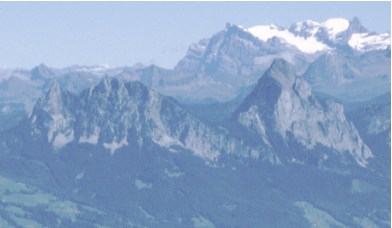
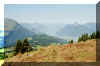
This easy route offers surprising views into valleys,
mountains, forests and alps. The closer we get to the rocky chunks of the
Mythen, the more we're being impressed.
| Hochstuckli-Rothenfluh |
km |
hrs |
Zug-Oberaegeri (Bus 1)
Oberaegeri-Sattel/Chairlift (Bus 9) |
|
|
Sattel-Mostelberg (Cale car)
or walk |
5 |
1.5 |
Mostelberg-(Herrenboden or Alp Engelstock)-
Mostelegg-Haggenegg-Holzegg-Rotenfluh |
7 |
2.5 |
| Holzegg-Rotenfluh |
1 |
0.5 |
Rotenfluh-Rickenbach Cable car
Rickenbach-Schwyz (Bus 3) |
|
|
| Schwyz-Zug (train) |
|
|
Shortly after
leaving the summit station with the Restaurant, the playgrounds, the Bob
rink, we get to the junction of the Engelstock circuit. To the right the lovely track will lead to
the Alp Engelstock and on to Mostelegg (the last 200 m up to Mostelegg is
Bitumen).
To the left a path is crossing the moor for Herrenboden. From there to
Mostelegg the road is Bitumen. At Mostelegg the path crosses alp meadows
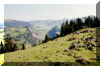
and brings us to Haggenegg. First we are welcomed by the little church
which offers a fantastic view over Schwyz valley. Later, on crossing the
hilltop we'll have free view into the white peaks of the alps of the
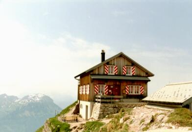
Glarus area. After Haggenegg (www.brunni.com)
we're closing in to the mighty rock walls of the Mythen.
After the Restaurant, to the right there is a side track down to Guenterigs
- Hasli and there proceeding up again to Holzegg ( + 1hr). At Guenterigs
there'll be a track up to Zwueschet Mythen. At the Alp
Restaurant Zwueschet Mythen (..."In between the Mythen") a short detour to the cross is
recommended, the view is superb (30 minutes return).
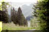
Proceeding to Holzegg the trail runs directly along the mountain. The
gravel on the track came from the rocky mountain flanks. From
Holzegg there are tracks to Ibergeregg,
into Brunnital/Alpthal (cable car), to Rotenfluh and down to Schwyz. The
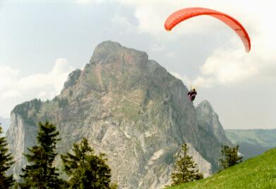
short walk over and up to Rotenfluh rewards us with remarkable views,
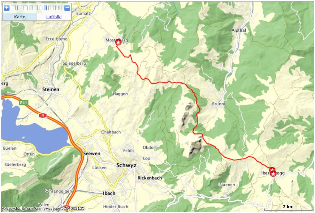
especially towards the chunky rock that's Grosser Mythen. Ibergeregg -
Holzegg - Haggenegg - Mostelberg
 Interactive
map: Interactive
map:
http://map.search.ch/d/jrjzmm3zt
GPS-routes:
GPS_Data/GPX-Ibergeregg-Mostelberg.zip
GPS_Data/GPX-Rotenflue-Mostelberg.gpx.zip
3.5
hrs.
From Holzegg two similar routes.
The Rotenflue-Mostelberg route is turning off after Haggenegg to Bannegg
and is then joining the usual route at Mostelegg and onwards to Mostelberg.
A Busline to Ibergeregg, the summit of the pass road Schwyz-Oberiberg, is operating
from Schwyz Post.
From Mostelberg to Sattel there is the cable car Stuckli Rondo with
connection to the Buslines to Oberaegeri or Schwyz.
Here a lovely alternative to the route mentioned above.
Right after Restaurant Haggenegg a Wanderweg Marker points to Schwaendi
/ Guenterigs.
To Schwaendi it's a steady descent, constantly accompanied by murmurs
of some mountain creeks.
After Schwaendi the gravel road is more or less level until Guenterigs.
The proceeding part to the cut between (=zwueschet) the Great and Small
Mythen is a pretty steep climb, passing short locations of rubble.
A Track for lovers of quiet tracks who don't mind some
"unnecessary" altitude meters.
top of page
On the way to Holzegg we've already used part of this track. The round
circuit tells many things about the region, nature, development. Quite an
attraction will be wintertime, since the track will be kept open.
| Erlebnispfad Engelstock |
km |
hrs |
Zug-Oberaegeri (Bus 1)
Oberaegeri-Sattel/chairlift (Bus 9) |
|
|
| Sattel-Mostelberg (chairlift) |
|
|
| Rundgang Mostelberg-Mostelegg-Mostelberg |
4 |
2 |
Mostelberg-Sattel (chairlift)
Sattel-Oberaegeri-Zug (bus) |
|
|
For the circuit a brochure with plan and some explanations and
additional information (in German) is available at the chairlift boots.
| Supplement to the brochure "Erlebnispfad
Engelstock":
The circuit has six thematic stations, dealing with News and
Surprises. There are explanations covering history, cultivation,
forestry, wildlife, water, air, wind...
Entering the forest in direction "Wald und Holz" there
are fairy tale figures cut in pine stumps, waiting to be discovered.
There are Haensel and Gretel, the Witch, Rapunzel, Rumpelstilzchen,
Till Eulenspiegel.
The "adventure track" will be kept open all year, also during
wintertime.
You may just as well use the track for a lovely walk only and enjoy the
views.
|
Wald und Holz: (Forest and Wood)
Animals and trees on Engelstock; Forest and Water; History of the
Schwyz Forest; Career to the top of a Pine tree; Animal search game. |
Verkehr und Tourismus: (Traffic and Tourism)
Regional History of Traffic; Limits of Mobility; CO 2 - Turntable
|
Luft und Atmosphaere: (Air and Atmosphere)
The Hull of the Air around the Earth; Radiation, Wind, Clouds; The
Weather; Wind play; Listening Funnel. |
Panorama:
Mountain panorama; Guessing game of the Landscape; Outing Targets in Innerschwyz (heart of Central
Switzerland). |
Wasser: (Water)
The element of Life; The Cycle of the Water; Life in the Creek;
Erosion; Water in Switzerland; Slide Gallery; Ear Trumpet;
Fireplace. |
Moor:
Landscape and Habitat; Culture;
Protection and Exploitation; Turntable Forest and Moor in
Comparison.
|
top of page
This hike is marked Panorama Weg, a fitting name.
| Ibergeregg to Hochybrig |
km |
hrs |
Zug - Schwyz (train)
Schwyz - Schwyz Post - Ibergeregg (bus's) |
|
|
Ibergeregg-Sternenegg-Windegg-Laucherenchappeli-
Spirstock-Chli Sternen
return: same track |
6.5
6.5 |
3
2.5 |
option:
from Sternen down to Seebli (Hoch Ybrig) by chairlift
and by other chairlift from Seebli up to Spirstock |
|
|
Ibergeregg - Schwyz Post - Schwyz (bus's)
Schwyz - Zug (train) |
|
|
After passing the nearby Marienkappelle, we're in the forest. The rocks
and the rich vegetation make this area most enjoyable.
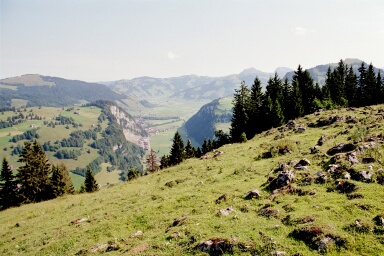
After the ascent in the forest we cross alp meadows and enjoy views over
valleys and into the alps.
 |
Fronalpstock,
Vierwaldstaettersee
Rigi Hochfluh |
From Laucherenchappeli (St Wendelin) to Spirstock it's a bit steeper, but the sight from
the top is excellent. We
proceed down the other side (there are about 200 stairs) to Nuehuettli (New hut). Up it goes on the perfect track near the rim of the
mountain to Sternen.
 |
View from Spirstock
towards Sternen |
Here we may descend to Seebli (by chairlift or on foot). Since the view is
so exceptional, the way back on the same route is probably
acceptable.
Before starting on this hike get the brochures about the
"Geologischer Wanderweg". It's available for free at the
Cable/Chairlift stations and from tourist offices. The map inside shows the
positions of the information boards. The tour can be shortened by using
the cable car and/or one of the chairlifts.
Large car parks are in Oberiberg at the Skilift (shortly after right turn
towards Iberegg/Schwyz: (The lift is closed during summer), and at the
chairlift and the cable car station.
| Roggenstock |
km |
hrs |
Zug-Arth Goldau-Einsiedeln (train)
Einsiedeln-Oberiberg/Laucheren
(Postauto to chairlift Laucheren)
or
Einsiedeln-Unteriberg/Weglosen
(Postauto to cable car Seebli) |
|
|
Church Oberiberg-Schoolhouse-Schlipfauweid-Tubenmoos-
Roggenegg-Roggenstock Ungaendern-Oberroggen-
Roggenhuette-Fuederegg-Steinboden
time for studying the boards |
7
|
3
2+ |
Fuederegg-Adlerhorst-Tubenmoos-Schlipfauweid-Oberiberg
or cable car/Chairlift |
6
|
1.5
|
Weglosen or Oberiberg to Einsiedeln (Postauto)
Einsiedeln-Arth Goldau - Zug (train) |
|
|
We start our ascent at the church. Walking on the Bitumen road towards
Roggenstock we arrive at the Schoolhouse with the
first Geology and Botany information board.
We proceed on the road till we get to the crossroads at the large
barn. A glance up in line with the
road to the mountain shows a peculiar building high up (a bit to the right
are cables of a ski lift) That's the Adlerhorst and roughly our first
target.
 |
On the geology track (board 2):
At Waag the left part of the mountain stopped moving, thereby
building a passage. |
We follow the road to the left.
After a short distance a big red/white arrow in the road points to the
right. A rather steep track is crossing the Bitumen road. Up to the top
there are more short cuts like this one, but they're not marked any more.
The next board is after the Alp Restaurant Schlipfenweid.
Either on the Bitumen road or on the unmarked short cuts, straight up, we ascend
to the Alp Tubenmoos. For Fuederegg and Roggenstock there is a track to
the right, passing Adlerhorst.
We're proceeding straight on, to the next board. Soon the road gives way
to a walking track. The next Geology board is at Alp Restaurant Roggenegg. Now
the track generally is more or less flat. Soon, a bit uphill we reach a
rocky part, Oberroggen. Lots of rocks that came off Roggenstock cover the
Alp meadows, the changing of nature a never ending process. From
here to the edge of Roggenstock at Ungaendern it's 30 Minutes steep walk
up to the fantastic lookout and back. Proceeding on the former track we
reach Roggenhuette.
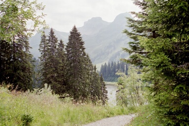
On a gravel road we finally reach Restaurant Fuederegg again with a
Geology board. Nearby is the pretty lake Seebli, the cable car for
Weglosen and the chairlift for Spirstock and Sternen.
 |
At Hoch Ybrig |
The chairlift
Laucheren to Oberiberg with another Geology board is about 20 Minutes from
here, at Steinboden. The last board is put up down in the valley near the
station and parking lot.
An additional board is at the mountain station of the Seebli cable car. Back
to Oberiberg we choose the track by Adlerhorst. The first part is a good
gravel road through forest. Later it's a track crossing Alp meadows.
After Adlerhorst, on a steep track we reach Tubenmoos. Here we're on our
"old" track. |