| |
Centrally
located in Switzerland:
Zug
belongs to
Central Switzerland
, into the „Pre Alps“
(Voralpen), just ahead of the „High Alps“ (Hochalpen).
The „Gotthard
Massive“ divides North and
South Switzerland
.
The exact geographical
midpoint of
Switzerland
is Alp Aelggi
(660.895/183.251) in the Melchsee Frutt area or 46°
47' 51 n 8° 14' 10 e.
In
the Zug area it’s still noticeable that huge glaciers, only shortly (10'000
years) before, have formed today’s landscape: in the East there
was the Linth glacier, from the West the Reuss glacier was approaching. In
the Menzingen area the two merged.
Scenically the “Zugerland” offers
something from everything: lovely landscape with brooks, lakes, fields,
woods, hills.
One step, and we’re in the high High Alps. Another short step, and we’re
entering different cultures: the
Ticino
in the South; to the East the Grisons; to the
West Valais
.
|
|
Gotthard
is an interesting watershed of European dimension:
The
Reuss begins in the Urserental, East of Furka, and flows in
northerly direction into Vierwaldstaettersee and near Brugg into Rhein.
The
Rhein commences to the East, in the Oberalppass area. In a wide bow
he is reaching out to stream into
Bodensee, then changes direction to the West, passing Basel, adjusts to a
Northerly direction and is heading into North Sea
at Rotterdam.
The
Rhone
starts its life on the
western side of Furka. The Rhone Glacier still exists (he is diminishing
rapidly) and is feeding the young
Rhone
. The „Rotte“ as
the river is called by the locals in the Valais, is joining lake Geneva
(Lac Léman) and is traversing part of Southeastern France to end up in
the Mediterranean Sea near Arles.
The
source of the
Ticino
is Southwest of
Gotthard. The river is running in the Bedretto valley, down the Leventina
valley, then demands some rest in the Lago di Maggiore. Finally,
after passing
Northern Italy
and merging with
Po
it reaches its final
destination in the
Adriatic Sea.
See
http://www.vier-quellen-weg.ch/home/
|
| Aletsch: |
A dramatic change in landscape and culture, here in the Wallis you find
another place in the sun. Protected by mountains there are those inviting
old chalets. On a terrace overlooking part of the Rhonetal is my favorite
holiday village Bettmeralp. The lower station of the cable car is combined
with the railway station "Betten" of the Furka Oberalp Bahn
(FOB). From Dec 7th 2019 the new Hub Fiesch will open: from MGB-train
station Fiesch, with Bus-Stop, there is direct access to the new Gondola
lift to Fiescheralp. |
| Andermatt, Gotthard: |
Gotthard Pass was for ages a most important route for crossing the alps.
Up to this days the importance has not changed. It is demonstrated by the
amazing constructions that you see everywhere: The main road, the
autobahn, the railway line, the protections against avalanches, the
tunnels (a new railway tunnel between
Erstfeld and Biasca is now under construction), the mountain railroad
between Goeschenen and Andermatt! But it's also a great place for hiking
tours. Near Andermatt in Realp, there is also a mountain golf course. |
| Goms |
This lovely valley on the eastern end of the Kanton Wallis is in
"stones throw distance". On the other side of Furka it's accessable
in a few Minutes by a rail tunnel. |
Horben
Lindenberg |
Sins to Lindenberg, that is the striking mountain range North East of
Zug. Horben is a very popular destination, - not only for hikers.
On the way we're crossing open country as well as forests, typical
"Mittelland" areas.
|
Leventina
Strada alta |
On the south side of Gotthard in Airolo you enter a different world, the
Italian culture. Often, when it's cold and foggy or raining in the north,
here it's sunny and warm, although between Goeschenen and Airolo are less
then 15 minutes for passing the tunnels. Hiking the strada alta is
quite popular, at least for the Swiss German. |
Mythen:
Hochstuckli-
Rotenfluh
Ybrig |
The landmark in the Schwyz region is a challenge for
people who love breathtaking views. Access is costing some sweat, but the
track from Holzegg is excellent.
The area between Sattel-Hochstuckli and Rothenfluh is a great area for
hiking.
In walking distance the popular region of Ybrig.
|
| Napf: |
A rural area, tidy villages, lots of hills and a mountain with
unsurpassed views. |
| Ob/Nidwalden |
Klewenalp: Access by cable car from Beckenried (ferry Gersau-Beckenried,
Autobahn A2 exit). A great area in summer and winter. Stanserhorn: Access from
Stans by romantic Stanserhorn funicular and cable car, or walk up from the
south side (cable cars at Wiesenberg and Wirzweli) and enjoy alpine sceneries.
Pass road Kerns-Aecherli (Wirzweli, Wiesenberg)-Dallenwil.
Emmetten: Niederbauen, Stockhuette are excellent starts for many hiking
trips in the area. Do the wildlife path from Emmetten/Niederbauen to
Stockhuette/Klewenalp.
|
| Pilatus: |
The other great mountain in easy reach. The steepest cogwheel railroad
from Alpnachstad, cable cars from Kriens (Three sections), Railroad/ship
in Alpnachstad. At Fraekmuent is a (summer-) Rodelbahn. |
| Rigi: |
One of my favorite mountains. It's very close, has a lot
of options for walking, excellent infrastructure, fantastic lookouts.
Trains in Arth Goldau and Vitznau (ship). Cable cars from Weggis (ship),
Kraebel (near Goldau), or
Kuesnacht (train, ship) to Seebodenalp, Vitznau to Hinterbergen, Vitznau
to Wisifluh, Gschwaend to Burggeist, Brunnen to Urmiberg.
|
| Stoos:
Fronalpstock
|
This holiday village has a lot of options for hiking, sport, leisure.
Access by a funicular from Schlattli (bus service from
Schwyz) or by cable car from Morschach (bus from Brunnen). Morschach is a modern Sport Center.
One of the most amazing walks atop the world, above the fog, on 1900m,
is the Panorama trail. It's also
suitable for "nonhikers".
|
| Titlis |
The world known Peak is easily accessible from Engelberg, a pleasant
holiday village. There is a wide range of hiking routes. Train from Luzern
(LSE, Luzern Stans Engelberg).
Across Jochpass there is another popular region: Melchsee-Frutt, again
with lots of attractions (one being fishing in the mountain lakes).
Melchsee-Frutt can be reached from Stoeckalp (cable cars) and by a
restricted access toll-road. Melchsee-Frutt is traffic free. |
Uri Reusstal
Haldi
Eggberge |
Haldi can easily be reached by cable car from Schattdorf, a
village between Erstfeld and Fluelen.
The cable car station to Eggbergen area is just one Bus stop from Fluelen
SBB station, or a 15 Minutes walk. Another station (to Rietlig/Biel) is at
Buerglen/Bruegg. |
| Weg der Schweiz: |
This is the hiking path around the southern part of Vierwaldstaettersee,
the Urnersee. It was officially opened in 1991 for the 700'th birthday of
Switzerland. The whole region is full of Swiss history, emotion,
literature, natural beauty. My favorite trip is from Brunnen to
Fluelen. |
Wildspitz:
(Rossberg) |
Another favorite, not only for me, with unsurpassed views. There are lots of tracks up to the
peak, e.g. from Zugerberg, Unteraegeri, Sattel,
Goldau, Walchwil. |
| Old passroads |
There are quite a few old mountain passes that make interesting hikes. |
| Extended |
Some Ideas for multiple day tours and possible overnight
stops.Notes about other regions. |
|
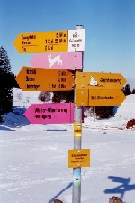
Although, sometimes during winter, hiking can get a bit tiring (heavy snow,
ice, sleet ("Pflotsch" we call it..).
Signs in pink mark cleared Winter walking tracks.
On other routes there are probably tracks left behind by some other hikers.
Some Popular winter Hikes, walks:
|
|


